
Cemetery Maps
Every space in Bohannon Church Cemetery has a unique address associated with our detailed digital maps making it easier than ever to locate specific sites anywhere on the property.
To view a full-size map on your device, select the Map for Screens button below. High resolution maps for printing are available by clicking the Printable Maps button.
Detailed instructions for navigating the cemetery are available below in the next section of this page.
Navigating the Cemetery
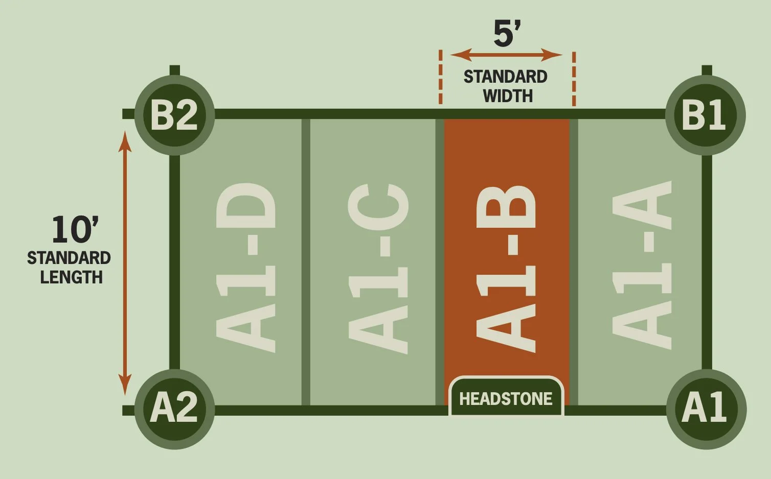
Standard grave spaces are 5 feet wide by 10 feet long and face east. Some older graves do not conform with this size, leading to uneven rows in our oldest section.
Rows in the cemetery are Lettered starting with “Row A” (in line with the back of the church building) and running to “Row S” (closest to Calfkiller Highway). Rows are spaced 1 grave length (10’) apart in all areas of the cemetery other than those near the oldest graves where lines have been adjusted to accommodate existing burials.
Columns in the cemetery are numbered starting with “Column 1” running parallel to the side of the church building along the southern edge of the cemetery and continuing north to “Column 16” near the fence that borders the property on the north. Columns are spaced 4 grave widths apart (20’).
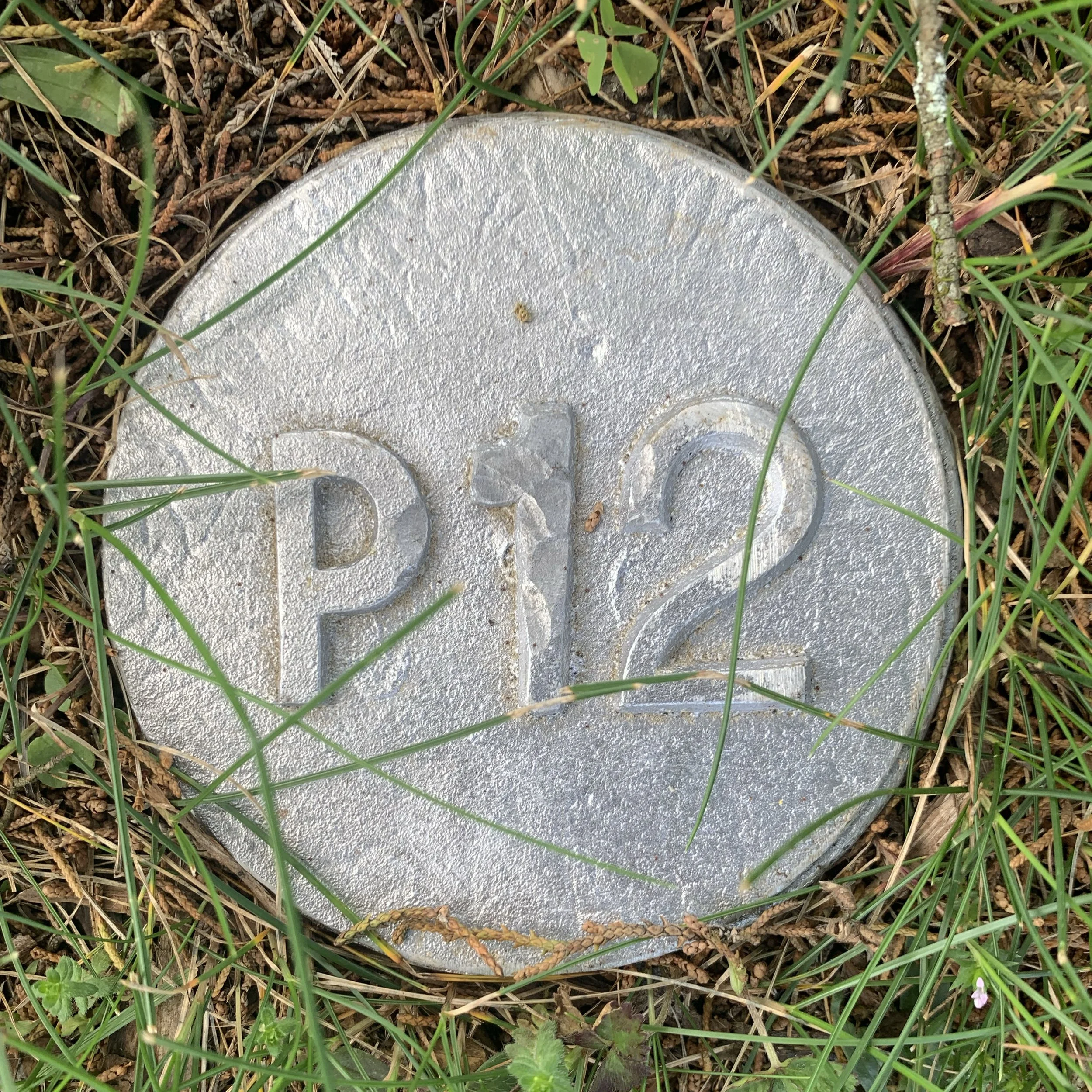
Metal ground pins are installed at each point where a Row intersects with a Column to create a map grid with pins reading “A1” or “M12,” etc. based on the two lines that cross at that point. The “A1” pin is located just north of the northwest corner of the church (the back corner closest to the cemetery). This system forms a grid with blocks that are 4 graves wide by 1 grave long or 20' wide by 10’ long in all but the oldest area of the cemetery.
The 4 graves in each block are addressed from south to north (right to left if you are facing towards Calfkiller Highway). If you are standing on the “A1 “ pin, the southern edge of the “A1-A” grave runs between the “A1” and “B1” pins with the “A1-B,” “A1-C,” and “A1-D” graves spanning the remaining distance between the “A1” and “A2” pins. In some areas, older layouts create extra grave spaces in the block. These graves are addressed as “A1-E” or “A1-F,” etc. until the next pin is reached.
For most graves, the headstone sits on the line for which the grave is addressed. This means that to find a grave with an address such as “K12-C,” you simply walk to the “K” row and head north (away from the church building) until you reach the “K12” pin. “K12-C” will be the third gave from that pin (between the “K12” and “K13” pins. By the same token, you could walk to the “12” column and walk to the “K” row to find the “K12” pin.
Row Adjustments
The following rows have been adjusted to accommodate graves from the earliest days of the cemetery.
Row A begins at A5
Row B begins at B5
Row G begins at G5
Row H runs from H1-H4 and stops. It begins again at H10.
Row I begins at I5
Row O begins at O3
Row P begins at P10
Row Q begins at Q4
Row R begins at R4
Row S begins at S5
Color Codes
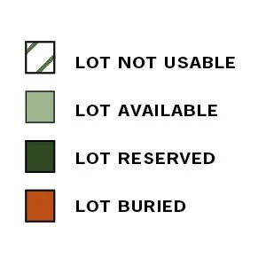
All graves on the map are assigned a color code based on their status at the time the current map was updated and released..
Lot Not Useable. Green stripes over a white background indicates that the space is unusable do to conflicts with nearby layouts or other issues preventing proper use.
Lot Available / Unreserved. The lightest green shade indicates the lot is available to be reserved.
Lot Reserved. The darkest green indicates the lot is already reserved.
Lot Buried. Graves marked in orange are already occupied.
Quick Links
Contact Us
As a volunteer-run community cemetery, we depend on people like you to preserve this sacred space. If you have concerns to report, need more information on the cemetery, just want to be kept informed on annual events and projects at the cemetery, please fill out secure form or send us a note at info@bohannoncemetery.com.